Island Gardens to London Bridge - North Bank – August 20th 2020
The Route
This section is the first of 3 that follow the Thames Path on the north bank of the river between Island Gardens and Teddington Lock.
Starting from Island Gardens at the bottom of the Isle of Dogs, this section makes its way up the west side, past Millwall and the Canary Wharf business district. It then continues westbound past Limehouse, Shadwell and Wapping. The last section takes in the more popular tourist attractions of St Katharine Docks, Tower Bridge and the Tower of London, ending at London Bridge.
This section is meant to be about 5 miles.
My Walk
As mentioned at the outset, within London the Thames Path can be walked entirely on the south bank or entirely on the north bank of the river. When I started my walks in January, I walked along the south bank from the Thames Barrier to Teddington Lock. For the sake of completeness, I decided I’d also do the north bank route from Island Gardens to Teddington Lock.
By the time I did this section, I’d already done 2 other walks from London Bridge to Teddington along the north bank, so I just had this short section to complete. When I was much younger, even though I’d never been there, I’d always thought of the Isle of Dogs as being rundown and deprived East End docklands; even the name put me off! It’s hard to believe that in less than 40 years it has been transformed to become the most prestigious place to live in London as well as being home to the Canary Wharf financial district. This walk would take me past tall skyscraper office buildings, luxury riverside apartment blocks and warehouse conversions but I never got to see where the ‘real’ people of the island live; I hope they haven’t all been driven out.
To get to the start of my walk, I got my usual train to Kings Cross, Northern Line to Bank, then the DLR to Island Gardens station. Emerging from the station, I walked the 200 yards to Island Gardens and the riverside. Island Gardens is a really pleasant 3 acre park situated on the southern end of the Isle of Dogs. It offers great views across the river to the Old Royal Naval College and the Cutty Sark at Greenwich. The striking dome topped entrance to the Greenwich Foot Tunnel is in the park. The tunnel was opened in 1902 and emerges on the other side of the river close to the Cutty Sark. The tunnel replaced an expensive and sometimes unreliable ferry service allowing workers living south of the Thames to reach their workplaces in the London docks and shipyards in or near the Isle of Dogs.
From Island Gardens, the path started on a quiet road, passing The Ferry House pub that claims to be the oldest pub on the island! For the next half mile or so, the path at times followed the riverside with modern apartment blocks to the right and at other times it followed a main road, until it reached the entrance to the former Millwall Outer Dock. The whole area around the dock has been regenerated since the dock closed to commercial traffic in 1981. The Docklands Sailing and Watersports Centre was established in 1989 at the western end of the dock which is where I was. A pair of cranes that were used for unloading ships have been retained against the backdrop of the Canary Wharf towers.
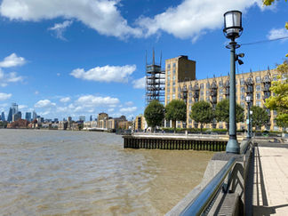
From Millwall Dock, the path continued along the riverside with apartment block after apartment block to the right of me. I soon arrived at Canary Wharf. The Canary Wharf development covers 97 acres of land and has 16 million square feet of office and retail space, centred around the 3 West India Docks that closed in 1981. The first buildings were completed in 1991, including 1 Canada Square, which became the UK's tallest building at the time and a symbol of the regeneration of Docklands. Rather than continuing along the path, I took a few minutes out to walk around the area. I imagine that most of the office workers were working from home, as I really didn’t see many people at all, other than guards protecting the buildings and people like me who were just having a mooch. It wasn’t quite a ghost town but not far off. Back by the river, I found a bench overlooking the City and ate my lunch.
After lunch the path took me past the entrance to Limehouse Basin. This provides a navigable link between the Regent's Canal and the Thames, through the Limehouse Basin Lock. Limehouse Basin was formerly known as Regent's Canal Dock and was used by seagoing vessels and lighters to offload cargoes to canal barges, for onward transport along the Regent's Canal. As with the rest of docklands, business declined and in 1969 the lock was closed to commercial vessels. Redevelopment began in the 1980s and today the basin is home to a marina, shops and cafes, overlooked by apartment blocks.
Continuing along the path, I came to Shadwell Basin which was once the eastern entrance to the London Docks. The 3 docks comprising the London Docks were closed in 1969 and were subsequently filled in. Shadwell Basin is the largest remaining body of water and is now a housing and leisure complex. The residential buildings are four and five storeys with façades of alternating open arches and enclosed structure, echoing the scale of traditional 19th century dockside warehouses. The striking red bascule bridge from the 1930s that spans the entrance to the basin, looked as if it had recently been repainted. Like Limehouse Basin, I found Shadwell Basin to be really attractive.
After Shadwell Basin the path kept to the streets for a while as it made its way through Wapping. The first building I passed was the Prospect of Whitby, a pub that claims to be the oldest riverside tavern, dating back to the 1520s. Continuing, the roads had retained their original cobbles and either side were plenty of original wharves, now converted to apartment blocks and offices. The Wapping I’d always thought of so negatively was really pleasant. As the path once again briefly continued alongside the river, I could see just how close I was getting to the City with The Shard dominating the skyline.
St Katharine Docks came up next. These were the smallest of London’s docks. They were the furthest upstream and dealt in luxury goods. They closed in 1968 and the start of regeneration started in 1970, after Taylor Woodrow were granted a 125 year lease by the Greater London Council on the proviso that it would be a mixed use development. Today the development includes a new hotel, offices, apartments, shops and restaurants, in addition to a marina. The Tower Hotel is certainly striking but in my opinion is hardly attractive. A very large pub called The Dickens Inn was created from one of the original warehouses, thought to have originally been owned by a brewery. The lock gate from the river into the dock is really interesting. Rather than being a pair of gates that are opened and closed from either side of the lock, this gate is lowered into the water to allow vessels to pass over it and it is then raised again.
On the other side of the river to St Katharine Docks I could see the full extent of Butler’s Wharf, which I couldn’t appreciate when I did the south bank walk. This is just one example of why I’m pleased I decided to do both the south and north bank routes. After passing Tower Bridge and The Tower of London, the path continued alongside the riverbank, before soon reaching London Bridge. As I said at the start of this diatribe, this short section from Island Gardens to London Bridge was the last section of the north bank route that I had left to complete. As such, I had now walked from the Thames Barrier to the source in Gloucestershire and within London, I had completed both the south and north bank routes. I felt this achievement on a hot August day was worthy of a small celebration, so after crossing London Bridge to get to the station, I celebrated at the Bunch of Grapes with a pint of appropriately named 'Proper Job'!!
Gallery


